Understanding landscape architecture includes more than just imagining appealing landscapes; it necessitates a full understanding of the terrain and its complexities. Mapping spatial spaces is a long-standing technique in landscape architecture. This procedure comprises gaining an understanding of the spatial-visual characteristics of the terrain using both manual and digitally created visualisations. The advancement of digital technology has boosted the use of digital visual representations in landscape study and design. Photomontages, computer models, 2D and 3D photorealistic visualisations and virtual reality (VR) settings are examples of these representations. Here, we highlight the critical role that Ordnance Survey maps serve in assisting landscape architects through the design process.
Download the latest update of OS maps here
Understanding Topography
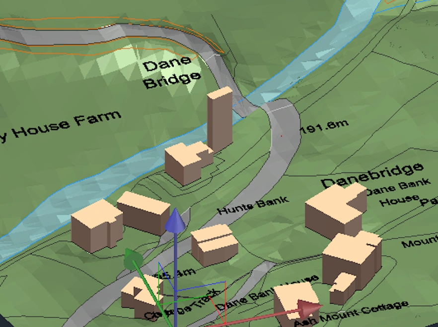
The start of a new project signifies the beginning of interpreting the terrain's complexities. 3D MasterMap® emerges as a useful asset in this early phase, comprising not only topographic information but also height details and massing data. This extensive mapping resource functions as a visual roadmap, similar to a detailed guide that landscape architects can methodically follow. These maps go beyond displaying elevation levels to provide a more detailed picture of the land's topography, using contour lines to create a more thorough perspective. The addition of natural elements enriches this resource even further, allowing landscape architects to detect minor peaks and dips in the terrain.
Site Planning and Site Analysis
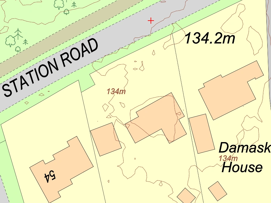
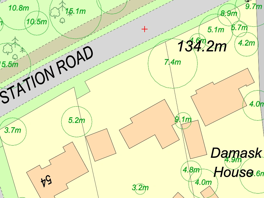
Landscape architects can use mapping and specifically 1m contours to analyse topographical characteristics, assess soil composition, and discover hydrological patterns, which aids in the selection of appropriate plant species and design aspects for a given location. The initial attention of a landscape projectis directed to the noticeably bright and contrasting characteristics, such as landmarks, wide areas, or unusual trees. The customer's and designer's focus naturally follows the contour lines separating the foreground, middle ground, and backdrop, as well as the skyline. This visual evolution allows people to fully appreciate the landscape. Importantly, the contours help guide the viewer's exploration and prediction of the spatial layout. Observers can determine and anticipate their future moves as they obtain an overview of the landscape. Notably, the visually appealing parts within the landscape are intrinsically seen as the most visually appealing, emphasising the importance of curves in orchestrating the visual story and 1m contours can be of great help to that visual exploration of the land.
Choosing the Right Scale
A thorough grasp of how the land is currently used is an essential component of any design endeavour. Ordnance Survey maps emerge as dependable guides in this regard, providing a thorough depiction of the existing features that create the terrain. Whether it's a verdant expanse of sweeping woodlands or an intricate web of urban developments, these maps serve as a thorough resource, establishing the framework for landscape architects to understand the canvas they're about to create. Ordnance Survey maps provide landscape architects with critical insights by meticulously outlining the diverse characteristics, from natural green spaces to man-made structures. These insights, in turn, serve as the foundation for educated decision-making, allowing landscape architects to negotiate and respect the land's existing qualities as they commence on the project.

Working with Nature
Landscape architects play a diverse role as environmental stewards, and Ordnance Survey maps are crucial allies in their drive to produce sustainable and ecologically sensitive solutions. These maps do more than just illustrate terrain; they also serve as useful tools by graphically identifying natural ecosystems, green spaces, and designated conservation areas. In the United Kingdom they can use the information offered by the National Tree Map™, which catalogues all trees taller than 3m, to make precise and strategic design interventions. Landscape architects can decide about tree species selection by analysing this comprehensive dataset and customising their choices to the current biodiversity of certain places. This information is especially useful for urban planning, since it allows architects to identify regions with low tree coverage and strategically plant new trees to reduce urban heat islands and improve overall environmental quality. Furthermore, the tree map is an important tool for site study, allowing landscape architects to understand how existing trees affect local factors such as sunlight exposure and wind patterns. The map data also supports in environmental impact evaluations, allowing architects to analyse the ecological relevance of trees, estimate carbon exposure, and prioritise tree preservation in development projects. Overall, the National Tree Map™ provides a plethora of particular data to landscape architects, permitting ecologically aware and contextually responsive design choices.
Historical Context
OS maps, in their complexities, reveal a site's historical context, providing a physical link between the present and the past. Ordnance Survey maps, which go beyond just representing terrain, become historical archives, pointing to ancient buildings, echoing echoes of ruins, and designating the grounds of archaeological sites. These maps add nuanced levels to the design process by presenting this historical richness. Landscape architects are enabled to create a design that respect and integrate the historical essence of the site because they know what formerly existed on the precise land they now wish to modify. Thus, Ordnance Survey maps become more than just instruments for spatial navigation, but also doorways to a better understanding of a landscape's historical narrative, allowing landscape architects to instill a feeling of continuity in their works. OS historical maps are ideal as they offer mapping dating back to the 19th century. You can find them here.
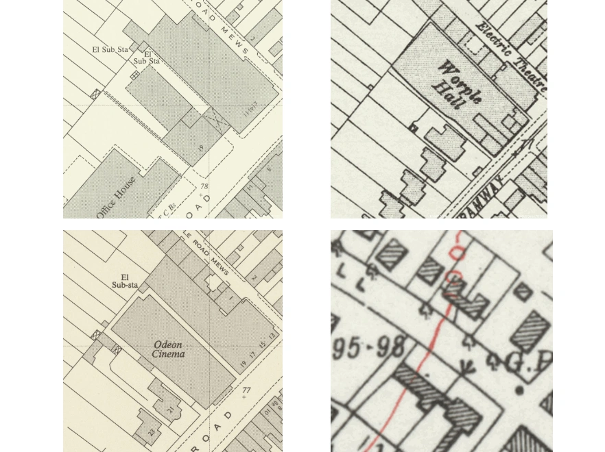
OS Historical maps showing how an area in London has changed over the years
Data Depth
Landscape architects use the capabilities of Ordnance Survey maps to overlay a plethora of additional data, such as soil types, vegetation zones, and geotechnical information, beyond the visible contours and features portrayed on conventional maps. This layered technique gives the map new depth, converting it from a two-dimensional representation into a full reference that speaks to the site's complexities. The integration of such different data not only deepens understanding but also provides landscape architects with a sophisticated understanding of the site's biological and geological complexities. Landscape architects receive crucial insights by effortlessly incorporating this supplemental information, which guides them in making the right design decisions. Understanding the nature of the soil allows for more careful landscaping options, understanding of vegetation zones guides planting techniques and knowledge of geotechnical elements aids in structurally sound designs. Essentially, this layered method converts Ordnance Survey maps into dynamic tools that transcend traditional limits, allowing landscape architects to traverse the complexities of the design process with precision and foresight.

Design Communication
Good communication is critical to a successful landscape project. Ordnance Survey maps are indispensable tools, bridging the communication gap between landscape architects, clients, stakeholders, and the general public. These maps, with their natural clarity and great detailing, serve as powerful visual aids that transcend the constraints of verbal communication. The detail of the information given on these maps acts as a common language ensuring that all parties involved understand the vision. The visual appeal and comprehensibility of Ordnance Survey maps improve the success of communication techniques whether discussing design concepts with clients, negotiating with stakeholders, or involving the general public in the project. OS maps also serve as strong media for communicating ideas and concepts clearly, encouraging common knowledge and communal dedication to the envisioned architectural journey. Below you can see how an architect used Ordnance Survey mapping to create a 3D model for a site appraisal for his client without the need of a topographic survey saving him over £1500 in fees.
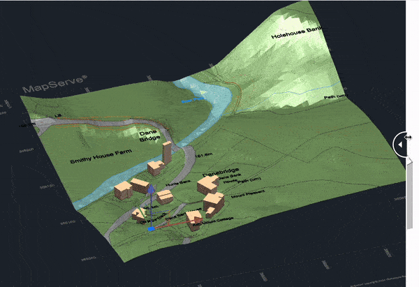
3D Model provided by Atelier Two
Legal Issues
Landscape architects can use Ordnance Survey maps to navigate the maze of planning restrictions, land-use policies, and other legal intricacies. These maps act as precise blueprints, laying out a site's geographical and legal dimensions. Ordnance Survey maps assist landscape architects in understanding the legal framework within which their creative ambitions must evolve by providing a visual picture of planning borders, land designations, and legal limits. This guarantees that the design is consistent with regulatory standards. Landscape architects who are equipped with this crucial information can incorporate legal considerations into their designs in a proactive manner, encouraging a harmonious integration of creativity and compliance.
To summarise, the importance of Ordnance Survey maps extends beyond their classification as tools; rather, they are essential companions in the landscape architect's toolset. They lead the design decisions of landscape architects with clarity and purpose. These maps, which serve as companions, contribute not only to the durability of the outdoor spaces envisioned by landscape architects, but also to their incorporation into the rich tapestry of the land's natural and historical environment. In essence, Ordnance Survey maps serve as constant guides, supporting a design process based on pragmatism, sensitivity, and harmonious coexistence with the intrinsic characteristics of the land.