The United Kingdom's construction industry is grappling with a significant skills gap, a challenge that threatens to impede the nation's ambitious infrastructure and housing goals. Recent reports highlight a pressing need for skilled workers across various trades, with estimates suggesting that an additional 250,000 construction workers will be required by 2028 to meet demand. This shortage is exacerbated by an ageing workforce, reduced apprenticeship intake and the impacts of Brexit and the COVID-19 pandemic.
To address this pressing issue, innovative solutions are being explored, among which mapping technologies stand out as a pivotal tool. By using Geographic Information Systems (GIS) and other mapping tools, the construction industry can enhance training programmes, streamline workforce planning and ultimately bridge the skills gap.
Access the latest professional OS maps
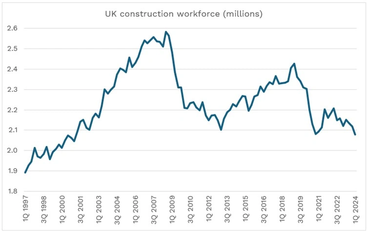
Image provided by the ONS
Understanding the Skills Gap in UK Construction
The skills shortage in the UK construction sector is a multifaceted problem. Factors contributing to this gap include an ageing workforce, with over 500,000 workers expected to retire within the next 10-15 years, and a decline in new entrants into the industry. Additionally, the aftermath of Brexit has led to a reduction in migrant labour, further intensifying the shortage.
This deficit poses significant risks to the timely delivery of infrastructure projects, housing developments, and maintenance works. The Construction Industry Training Board (CITB) estimates that to meet the projected demand, the industry must recruit an additional 50,300 workers annually.
Image provided by the ONS

The Role of Mapping Technologies in Addressing the Skills Gap
Mapping technologies, particularly GIS, offer transformative solutions to the challenges faced by the construction industry. These tools facilitate better planning, training, and resource allocation, thereby mitigating the impact of the skills shortage.
1. Enhancing Training Programmes
Integrating mapping tools into training curricula can provide trainees with a comprehensive understanding of construction sites and project layouts. For instance, the Supply Chain Sustainability School has developed a Materials Exchange Platform (MEP) mapping tool that allows users to locate materials and resources within a 30km radius. This tool not only aids in resource management but also serves as a practical training aid for apprentices to familiarise themselves with real-world scenarios.
Moreover, GIS-based simulations enable trainees to visualise site conditions, plan logistics, and anticipate challenges, thereby enhancing their problem-solving skills and readiness for actual projects.
2. Optimising Workforce Planning
Mapping technologies can identify regions with acute skills shortages, allowing for targeted recruitment and training efforts. By analysing geospatial data, companies can pinpoint areas where specific trades are in short supply and collaborate with local training centres to develop tailored programmes.
For example, the Construction Products Association (CPA) has highlighted the demographic crisis in the construction workforce, with a significant portion nearing retirement. Utilising mapping tools to visualise this data can assist in forecasting future shortages and implementing proactive measures.
3. Facilitating Remote Collaboration and Project Management
The advent of digital mapping solutions has revolutionised project management by enabling remote collaboration. Platforms like Procore's construction mapping software provide interactive maps that allow team members to track progress, view site photos, and access project data in real-time, irrespective of their physical location.
This capability is particularly beneficial in the context of a skills shortage, as it allows experienced professionals to oversee multiple projects remotely, provide guidance, and ensure quality standards without the need for constant on-site presence.
4.Permit and Compliance Processes
Navigating the regulatory landscape is a complex aspect of construction projects. Mapping tools can simplify this by providing detailed visualisations of zoning laws, environmental restrictions, and land use patterns. This information enables construction firms to plan projects more efficiently, reducing delays caused by compliance issues and allowing the existing workforce to focus on active projects.
Case Studies: Mapping Technologies in Action
EKFB's Use of GIS for Temporary Works Management
EKFB, a joint venture working on large-scale infrastructure projects, has effectively utilised GIS tools to manage temporary construction works. By integrating various GIS applications, they achieved significant cost savings and improved efficiency in project execution.
Structural Engineering and 3D Visualisation
Structural engineers are increasingly adopting mapping solutions for tasks such as 3D visualisation and geospatial data analysis. These technologies enhance the accuracy of designs and facilitate better decision-making processes, contributing to more efficient project delivery.
Challenges and Considerations
While the benefits of mapping technologies are substantial, their implementation is not without challenges:
-
Cost and Resource Allocation: Investing in advanced mapping tools and training personnel can be costly, which may be a barrier for smaller firms.
-
Data Accuracy: The effectiveness of mapping tools is contingent upon the accuracy of the data inputted. Inaccurate or outdated data can lead to flawed analyses and decisions.
-
Integration with Existing Systems: Ensuring compatibility between new mapping technologies and existing project management systems requires careful planning and execution.

Future Outlook
The integration of mapping technologies in the construction industry is poised to become more prevalent as the sector seeks innovative solutions to bridge the skills gap. Embracing digital tools not only enhances efficiency but also attracts a younger, tech-savvy workforce, thereby contributing to the long-term sustainability of the industry.
In conclusion, mapping technologies offer valuable avenues to address the skills shortage in the UK construction sector. By enhancing training programmes, optimising workforce planning, facilitating remote collaboration, and streamlining compliance processes, these tools can play a pivotal role in bridging the gap and ensuring the successful delivery of future construction projects.