We’re excited to announce the addition of the Ordnance Survey’s (OS) latest data feature—the Field Boundary layer—to our OS MasterMap® offering in CAD format. This new layer provides highly detailed and precise data on the boundaries of fields across the UK, capturing the exact outlines of hedgerows, fences, walls, and other physical demarcations that define rural and agricultural landscapes. For professionals in building, planning, architecture, and surveying, this enhancement offers a new level of accuracy and detail that can significantly improve project outcomes.
Download OS MasterMap with field boundaries®
What is the Field Boundary Layer?
The Field Boundary layer is an advanced dataset created by Ordnance Survey as part of its National Geographic Database (NGD). This layer meticulously maps the physical boundaries of fields, providing comprehensive coverage of both natural and artificial boundaries such as hedgerows, fences, ditches, and walls. By integrating this layer into our OS MasterMap® in CAD format, we are equipping professionals with the precise, up-to-date data needed for a wide range of applications.
The Field Boundary data is derived from high-resolution aerial imagery, LiDAR, and other advanced geospatial technologies, ensuring that it meets the highest standards of accuracy. This layer is especially valuable for those working on projects in rural and semi-rural areas where understanding the exact layout and limits of the land is crucial.
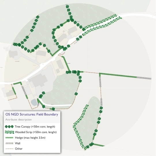
Field Boundary categories, including Tree Canopy, Wooded Strip, Hedge and more, provided by the OS
Key Features and Technical Specifications
The Field Boundary layer adds significant value to OS MasterMap® with the following technical features:
-
Detailed Boundary Types: The layer differentiates between various types of boundaries, such as hedges, walls, fences, and ditches, allowing users to understand the specific nature of each boundary on the map. This differentiation is critical for applications that require an understanding of the physical characteristics of a landscape, such as environmental impact assessments or agricultural planning.
-
High-Resolution Accuracy: The data is captured using high-resolution aerial photography and LiDAR, ensuring that boundaries are mapped with precise accuracy. This high level of detail is particularly beneficial for surveyors and architects who need reliable data to inform their designs and planning.
-
Continuous Updates: The Field Boundary layer is part of the OS National Geographic Database, which is daily updated to reflect changes in the landscape. This ensures that the data you are working with is always current, making it ideal for projects that require up-to-date information.
-
Compatibility with CAD: Our integration of the Field Boundary layer into OS MasterMap® in CAD format means that this data can be seamlessly incorporated into your existing CAD projects. This allows for direct application in design, planning and analysis, saving time and reducing the risk of errors associated with data conversion.
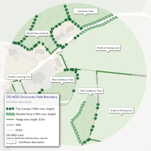
Field Boundary features and the adjacent topographic areas they typically surround, provided by the OS
Use Cases for the Field Boundary Layer
The introduction of the Field Boundary layer into OS MasterMap® in CAD format opens up new possibilities for a variety of sectors. Here’s how different industries can benefit from this detailed data:
1. Building and Construction
In the building and construction industry, understanding the precise boundaries of land is essential for planning and development. The Field Boundary layer provides exact demarcations of property lines, enabling architects and builders to design structures that respect these boundaries. For example, when planning new developments in rural areas, this layer can help avoid encroachment on agricultural land or protected areas. It also aids in the accurate placement of infrastructure, ensuring compliance with planning regulations.
2. Urban and Rural Planning
Urban and rural planners can leverage the Field Boundary layer to gain a deeper understanding of the landscape they are working with. For rural developments, this layer offers insights into how land is divided and used, which is crucial for projects that must consider agricultural activity, conservation efforts, and land use regulations. In urban fringe areas, where the transition from rural to urban can be complex, the Field Boundary layer provides planners with the detailed data needed to manage this transition effectively.
3. Architecture
Architects can use the Field Boundary layer to enhance their site analysis and design processes. By incorporating accurate boundary data into their CAD models, architects can create designs that are more closely aligned with the natural landscape. This is particularly important in projects that require sensitivity to the existing environment, such as designing eco-friendly buildings or integrating new structures into historic landscapes. The layer’s detailed differentiation between boundary types also allows architects to factor in the aesthetic and functional aspects of the landscape into their designs.
4. Surveying
For surveyors, the Field Boundary layer is an invaluable tool for accurate land measurement and documentation. The high-resolution data ensures that surveyors can identify and record the exact location of boundaries, which is critical for tasks such as property surveys, land parcel division, and legal disputes. Additionally, because the data is compatible with CAD, surveyors can easily integrate it into their existing tools, enhancing the accuracy and efficiency of their work. Boundary disputes can also benefit from this addition.
How the Field Boundary Layer is Created
The Field Boundary layer is generated through a combination of advanced geospatial technologies. Ordnance Survey employs high-resolution aerial imagery and LiDAR (Light Detection and Ranging) to capture the physical characteristics of the landscape. These technologies provide the precise elevation and surface data necessary to map boundaries accurately. The data is then processed and classified, distinguishing between different boundary types such as hedgerows, fences, and walls. This classification is crucial for applications that require specific knowledge of boundary materials and conditions.
The layer also undergoes continuous updating as part of the OS National Geographic Database. This means that any changes to the landscape—such as the removal of hedgerows or the construction of new fences—are reflected in the dataset, ensuring that users have access to the most current information available.
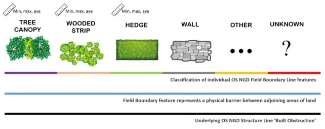
How the field boundary layer is created, provided by the OS
Things to Consider
While the Field Boundary layer offers significant advantages, it’s important to be aware of its limitations. For example, the data might not capture very recent changes to the landscape immediately, depending on the update cycle. Additionally, while the layer provides detailed boundary types, it does not include ownership information, which may be required for certain legal or planning processes. Users should supplement this data with other sources where necessary to ensure comprehensive coverage for their specific needs, such as our freehold boundaries layer.
Freehold boundaries layer
The integration of Ordnance Survey’s Field Boundary layer into OS MasterMap® in CAD format represents a critical advancement for professionals requiring precise geospatial data. This layer’s inclusion provides enhanced granularity in boundary delineation, offering architects, planners and surveyors the ability to incorporate detailed, topologically accurate information directly into their CAD projects. The high-resolution data, combined with continuous updates, ensures that projects are underpinned by the most current and reliable boundary information available.