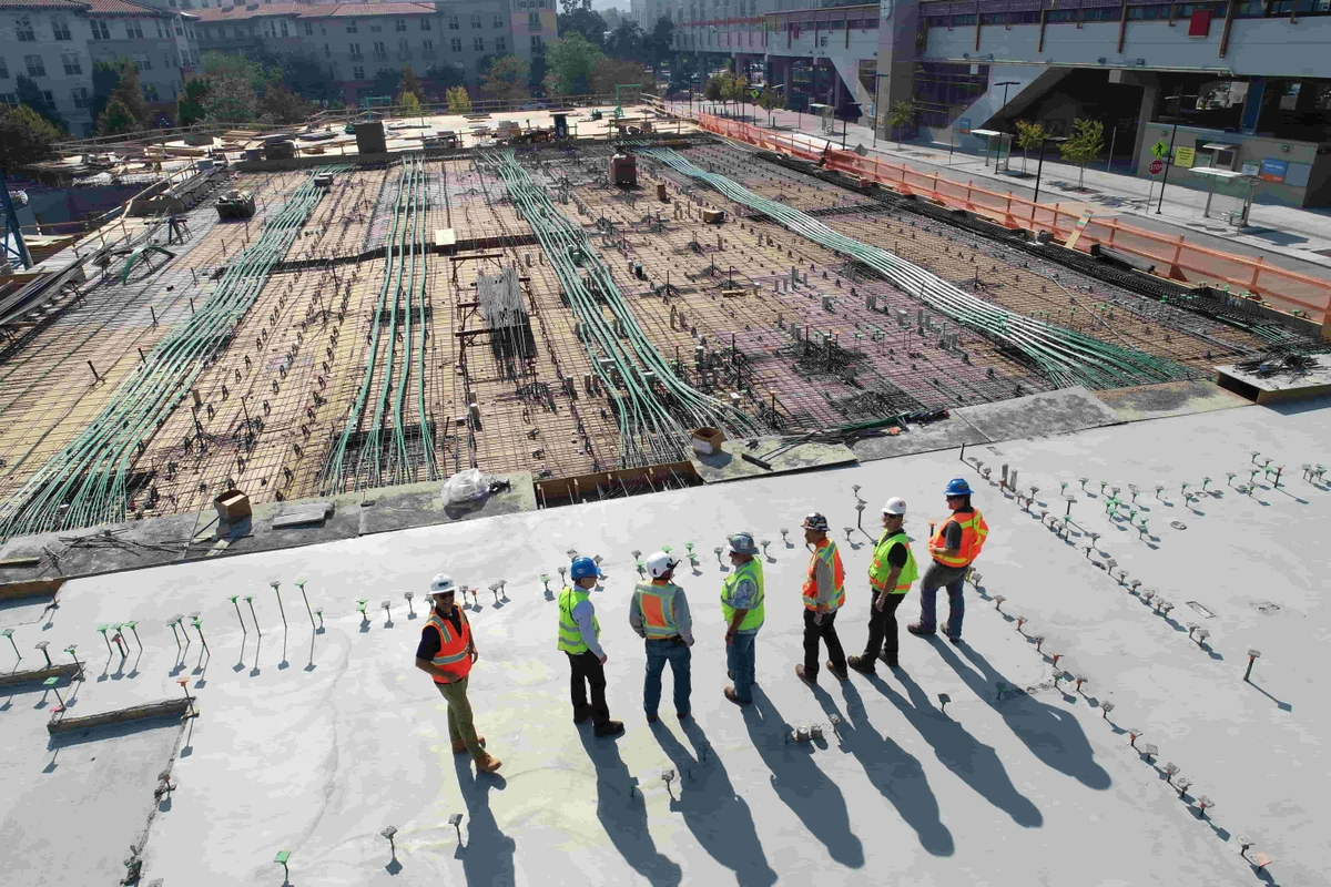
The United Kingdom's construction industry is currently navigating a period of economic slowdown, with forecasts indicating a contraction of 2.1% in 2024 before a modest recovery of 2.9% in 2025. This downturn presents significant challenges for professionals such as architects and surveyors, who must find innovative ways to maintain productivity and profitability. One promising avenue is the integration of advanced mapping technologies to enhance construction efficiency.
Access the latest OS mapping
Understanding the UK Construction Slowdown
Several factors contribute to the current slowdown in the UK's construction sector. Elevated interest rates have led to decreased demand in private housing, with major housebuilders reporting a 30-40% decline in interest. Additionally, economic uncertainties and increased costs have resulted in project delays and cancellations, particularly in infrastructure developments.
Labour shortages further exacerbate the issue, with skilled workers in high demand but in short supply. Brexit has impacted the availability of European labour, leading to increased wages and longer project timelines. Moreover, supply chain disruptions and rising material costs have made it difficult for contractors to stick to budgets, leading to stalled projects and reduced profitability.
Government Policies and Industry Responses
The UK government has introduced measures to support the construction industry, including investment in public infrastructure projects and incentives for sustainable building. The push for net-zero carbon emissions has also created opportunities for firms specialising in green construction and energy-efficient designs. Additionally, the adoption of digital technologies, including construction mapping solutions, is being encouraged to drive productivity improvements.
With these challenges and opportunities in mind, the construction sector must adopt strategic measures to improve efficiency. Mapping technologies are emerging as a key solution to streamline operations and mitigate the impact of economic downturns.
The Role of Mapping Technologies in Boosting Efficiency
Advanced mapping technologies have emerged as vital tools in modern construction, offering numerous benefits:
1. Precision in Planning and Design
High-resolution mapping allows for detailed site analysis, enabling architects and surveyors to make informed decisions during the planning phase. Geographic Information Systems (GIS) and LiDAR (Light Detection and Ranging) provide precise terrain models, helping professionals assess site conditions, potential risks, and optimal building layouts. This precision reduces the likelihood of errors and costly revisions, improving overall project efficiency.
2. Enhanced Project Management
Integrating GIS with Building Information Modeling (BIM) provides a comprehensive view of the project lifecycle. BIM enables detailed 3D modeling of structures, allowing for clash detection and early resolution of design conflicts. When combined with GIS, it offers insights into environmental factors, zoning restrictions, and underground utilities, ensuring smoother project execution and reducing unforeseen disruptions.
3. Improved Communication and Collaboration
Accurate maps and models serve as a common reference point for all stakeholders, enhancing communication and reducing misunderstandings that can lead to delays. Cloud-based mapping solutions enable real-time data sharing among architects, engineers, contractors, and clients, ensuring that everyone is on the same page throughout the project.
4. Environmental Impact Assessment
Sustainability is becoming an essential aspect of construction projects. Mapping technologies assist in assessing environmental factors such as flood risks, soil composition, and biodiversity impact. This information is crucial for obtaining planning permissions and ensuring compliance with environmental regulations. It also helps architects design energy-efficient buildings by analyzing factors like solar exposure and wind patterns.
5. Cost Reduction and Resource Optimization
By providing accurate site data, mapping technologies reduce the need for on-site surveys and rework. Drones equipped with high-resolution cameras and LiDAR sensors can quickly capture detailed topographical data, eliminating the need for manual surveys that are time-consuming and expensive. This translates to significant cost savings and faster project completion.
Implementing Mapping Technologies: Practical Steps
For professionals looking to leverage mapping technologies, consider the following steps:
1. Invest in Training
Ensure that your team is proficient in the latest mapping tools and software. Continuous professional development is crucial in keeping up with technological advancements. Many institutions offer specialized training in GIS, BIM, and drone mapping.
2. Collaborate with Experts
Partner with firms specializing in geospatial services to access high-quality mapping data and insights. Working with experienced surveyors and GIS specialists can provide your project with the accuracy and efficiency required to succeed.
3. Integrate Systems
Combine mapping technologies with existing project management and design tools to create a seamless workflow. Many software solutions offer integrations with BIM, CAD, and GIS platforms, ensuring compatibility and ease of use.
4. Stay Informed
Keep abreast of emerging technologies and industry trends to remain competitive. Regularly attending industry conferences, networking with professionals, and subscribing to construction technology publications can help you stay ahead of the curve.
5. Adopt Cloud-Based Solutions
Cloud-based mapping technologies enable remote access to project data, allowing for real-time updates and improved decision-making. These solutions enhance collaboration between teams, reduce paperwork, and improve overall efficiency.
Case Studies: Success Stories in the UK
HS2 High-Speed Rail Project
The HS2 project, the UK’s largest infrastructure initiative, has extensively used GIS and LiDAR for route planning and environmental assessments. These technologies have helped in optimizing the rail alignment, minimizing ecological impact, and streamlining land acquisition processes. By leveraging geospatial data, HS2 has been able to reduce project delays and ensure more efficient construction operations.
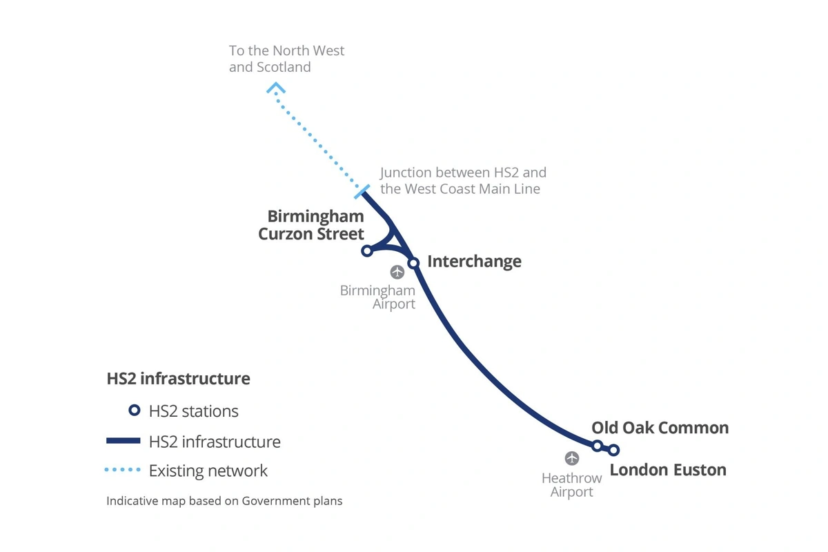
A route map displaying the HS2 infrastructure and its link to the West Coast Main Line, providing connections to the North West and Scotland. Image by HS2 Ltd.
London’s Smart City Initiatives
London has implemented GIS-based urban planning strategies to enhance infrastructure development. The city’s digital twin, a virtual model of the urban environment, integrates real-time data from sensors and mapping technologies to optimize land use, monitor construction progress and improve traffic management. This approach has led to more sustainable and efficient urban development.
Flood-Resilient Housing Developments
With climate change increasing the risk of flooding in the UK, developers are using mapping technologies to assess flood-prone areas and design resilient housing solutions. Projects in regions such as Yorkshire and the Thames Valley have integrated GIS-based flood modeling to determine safe building elevations and drainage strategies, ensuring long-term sustainability and compliance with regulatory standards.
Future Trends in Construction Mapping Technologies
As technology continues to evolve, several trends are shaping the future of construction mapping:
-
Artificial Intelligence and Machine Learning: AI-driven analysis of mapping data is enhancing predictive modeling, enabling more accurate forecasting of site conditions and potential risks.
-
Augmented Reality (AR) and Virtual Reality (VR): AR and VR applications are allowing architects and engineers to visualize projects in a virtual space, improving design accuracy and stakeholder engagement.
-
Automation and Robotics: Autonomous drones and robotic surveyors are increasing efficiency in data collection, reducing the reliance on manual labor for mapping and site analysis.
-
Blockchain for Data Security: Secure and immutable mapping data records are being explored through blockchain technology, ensuring transparency and reliability in project documentation.
-
5G and Real-Time Data Processing: The introduction of 5G networks is enhancing real-time data transmission, enabling faster updates and improved accuracy in mapping applications.
How AI can help mapping queries. Provided by xmap
Amidst the current slowdown in the UK construction industry, embracing advanced mapping technologies offers a pathway to enhanced efficiency and resilience. By integrating these tools into their workflows, architects, surveyors, and other professionals can better navigate the challenges of today’s market and position themselves for future success.