A Comprehensive Guide to Mastering Terrain Understanding
Topography maps play a pivotal role in various industries, including architecture and the broader building industry. These detailed maps provide essential information about the natural features and terrain of a specific area, aiding architects, engineers, and construction professionals in making informed decisions throughout the design and construction process. In this comprehensive guide, we'll delve into the fundamentals of topography maps, their significance, and how they are utilized in the field of architecture and construction.
Download 1m contours for your plans here
Understanding Topography Maps
A topographical map, also known as a contour map or terrain map, is essentially a thorough representation of the surface elements that make up a landscape. These include a wide range of factors, from height and slope to valleys, ridges, and other distinguishing physical features that define the terrain's topography. Topography maps are methodically created using a methodology known as surveying, which comprises precisely measuring and charting ground elevation points. This endeavour is aided by a variety of specialised equipment, including but not limited to total stations and GPS devices, which allow surveyors to collect precise data, ensuring the integrity and trustworthiness of the eventual map depiction.
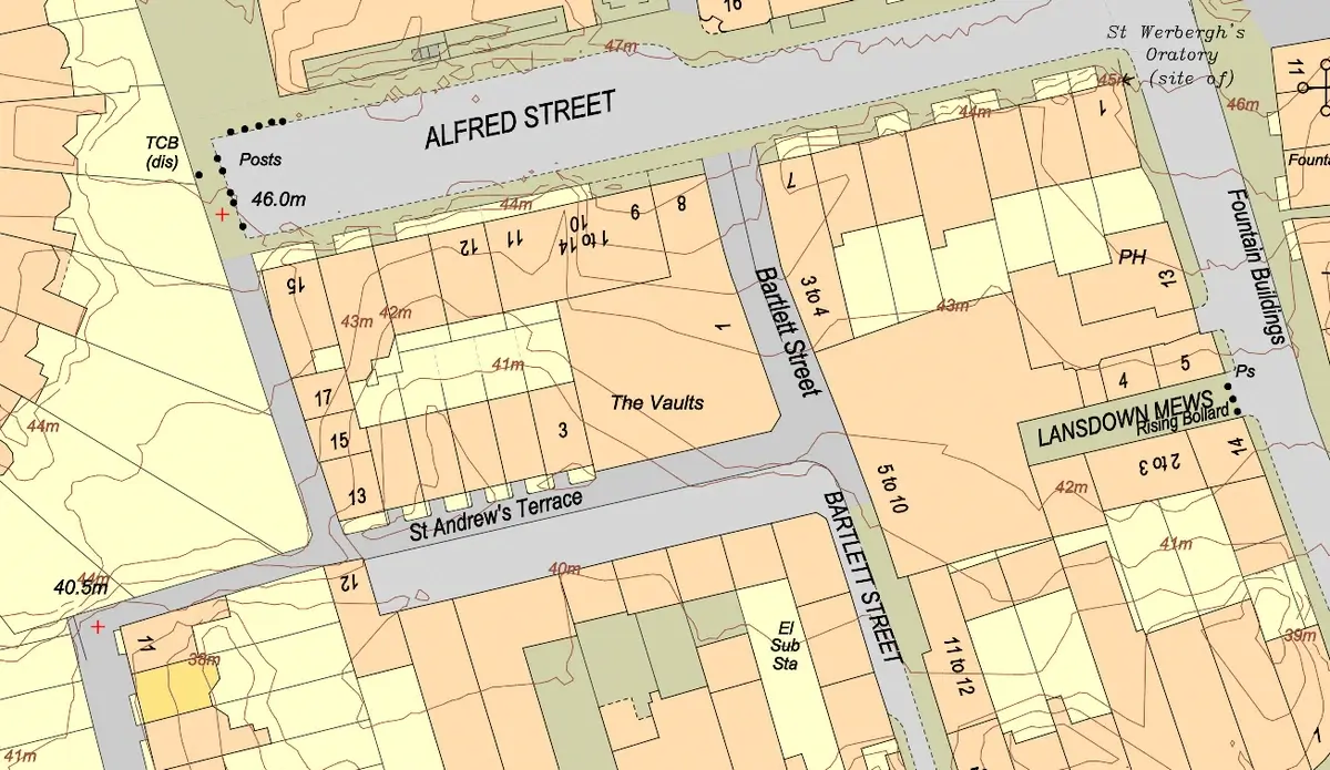
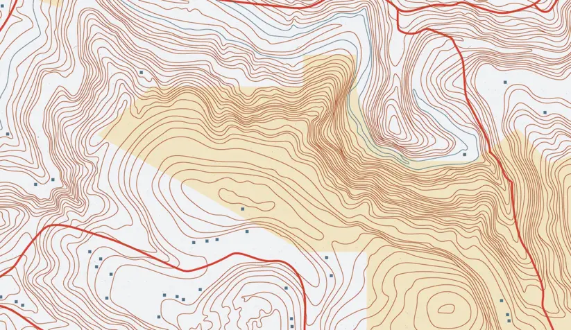
Contour map of an urban (image 1) and a rural area (image 2)
Key Components of Topography Map
Contour Lines
One of the most defining features of topography maps, which is essential to their usefulness and utility, is the network of contour lines that run across the map's surface. They are the principal means of connecting locations of equal elevation, allowing for a more subtle and detailed visualisation of the terrain's undulating topography. This trait is especially significant in the context of the United Kingdom's geography, which has a wide range of topographical features, from rolling hills in the countryside to severe terrain in the highlands. An understanding of contour lines is essential in architecture because it influences site selection, building orientation, and structural design decisions. Architects and urban planners use this data to optimise building sites, reduce excavation and grading requirements, and address potential issues caused by uneven terrain. Furthermore, in a country with a rich architectural past and a plethora of historical sites such as the UK, topography maps play an important role in maintaining and improving the built environment. They contribute to the preservation of cultural heritage monuments, inform restoration efforts, and guide the sustainable development of urban areas, ensuring that architectural interventions are harmonious with the surrounding landscape. Thus, contour lines are far more than just cartographic representations; they shape the very fabric of architectural design and the built environment in the United Kingdom and elsewhere.
Elevation Points
In addition to contour lines, topographical maps frequently include elevation points or spot elevations, which provide exact elevation values at specific spots across the map. These elevation points are crucial reference marks for architects and engineers, allowing them to accurately determine the height of various terrain features and assess elevation changes within a given site. This granular elevation data is critical in architectural design and construction planning, guiding decisions about building placement, foundation design, and site grading. Architects use this data to ensure that projects are built at appropriate altitudes, maximising views while minimising potential hazards like flooding or unstable terrain. Furthermore, in urban environments, elevation points help to construct accessible infrastructure by guiding the placement of roadways, walkways, and utilities to meet different terrain levels. By incorporating elevation points into their designs, architects may construct sustainable, resilient structures that blend into the natural terrain while satisfying the demands of occupants and communities.
Relief Representation
Topography maps use shading and colour gradients to portray elevation variations and the terrain's three-dimensionality, which improves map reading and spatial interpretation. In architecture, this depiction is critical for predicting site difficulties and seamlessly integrating designs with the terrain. By analysing elevation patterns, architects may handle difficulties like steep slopes and drainage concerns, resulting in contextually appropriate and aesthetically beautiful solutions. Furthermore, in urban planning, this visualisation helps to locate infrastructure parts efficiently while minimising environmental impact. Thus, shading and gradients in topography maps are invaluable tools for architects, enabling informed decision-making and sustainable design practices.
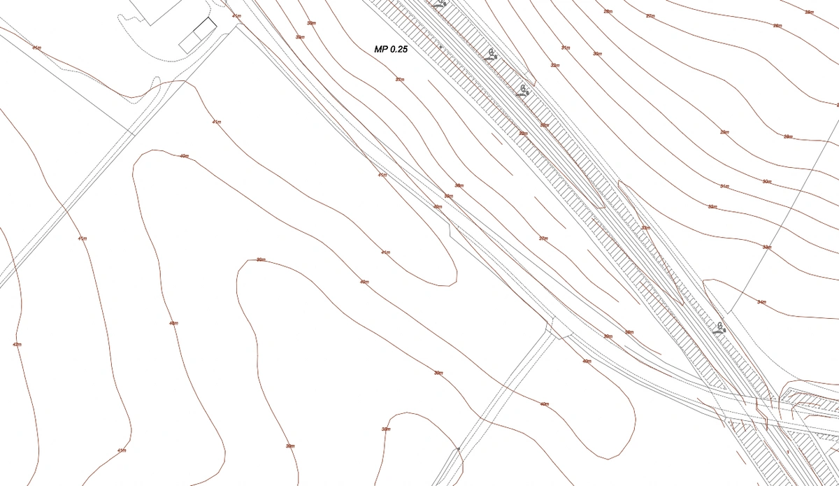
Contour & elevation point map, Scotland
Applications in Architecture and Construction
Topography maps serve various purposes in architecture and construction, influencing site planning, building design, and infrastructure development. Here's how professionals in the building industry can use topography maps:
Site Analysis and Selection
Architects rely heavily on topographical maps to undertake detailed assessments of potential building sites, using them as critical tools in determining the viability of the terrain for construction projects. These maps contain a variety of information, enabling builders to investigate slope gradients, drainage patterns, soil conditions, and natural features. Architects acquire vital insights by meticulously analysing the data shown on these maps, allowing them to discover appropriate construction placements and site development. Furthermore, topography maps allow for a more full awareness of the surrounding environment, including features such as vegetation coverage, water bodies, and nearby infrastructure, all of which play important roles in site selection. This thorough examination enables architects to decide how not only maximise the possibilities of the site, but also handle potential obstacles and mitigate risks associated with the chosen location. Furthermore, by incorporating new mapping technology and data analysis methodologies, architects may improve the depth and accuracy of their site assessments, ensuring that buildings are not only visually appealing, but also sustainable and resilient to environmental variables.
Grading and Earthwork Design
Topography maps provide essential data for grading and earthwork design, informing decisions regarding land leveling, cut-and-fill operations, and drainage systems. Architects and engineers use the elevation information from the map to create grading plans that ensure proper water runoff and foundation stability.
Environmental Considerations
Understanding the topography of a site is crucial for assessing environmental factors such as flood risk, erosion potential, and habitat preservation. Architects incorporate this information into their designs to minimize environmental impact and comply with regulatory requirements.
Visualisation and Communication
Topography maps serve as valuable visual aids during project planning and communication with clients, stakeholders, and regulatory agencies. Architects use the maps to illustrate proposed design concepts, highlight site constraints, and convey the spatial context of the project.
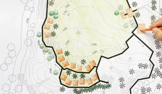
Contour map used in an architectural site analysis
In conclusion, topography maps serve as indispensable tools for architects, engineers, and various professionals within the construction and urban planning sectors. These maps offer comprehensive insights into the intricate physical features of the land, including elevation changes, slopes, and natural landmarks. Such detailed information is crucial for making informed decisions at every stage of the design and construction process. Architects rely on topography maps to optimize site planning, ensuring that structures harmonize with the surrounding environment while mitigating potential challenges posed by the terrain. Moreover, these maps facilitate the enhancement of design efficiency by enabling architects to anticipate and address issues such as drainage, soil stability, and accessibility. Through the integration of topography mapping into architectural practice, professionals can foster a holistic approach to project management, emphasizing sustainability and environmental stewardship. By leveraging the wealth of data provided by topography maps, architects can not only create aesthetically pleasing and functional designs but also contribute to the long-term vitality and resilience of built environments.
For more information on 1m contours or to order go to MapServe®.
You can also check our Contour Maps guide here.