When planning any development that involves vehicular movement—whether it’s for a residential estate, a logistics hub, or a redesigned car park—one critical consideration is whether the vehicles using the space can move safely and efficiently. This is where swept path analysis comes into play. For anyone involved in the planning, design, or approval of such projects, understanding swept path analysis is crucial.
In this blog post, we’ll dive into what swept path analysis is, why it’s important, and how you can obtain one, including how to get the necessary mapping from MapServe® to support the analysis.
Download OS CAD maps for your swept path analysis
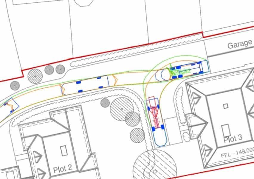
Swept Path Analysis example, Image provided by Lapworth Architects
What Is Swept Path Analysis?
Swept path analysis is a process used to simulate and assess the movement of vehicles through a given space. The term "swept path" refers to the area a vehicle occupies when it makes a turn. This includes not only the space the vehicle physically occupies at any given moment but also the additional space required as it maneuvers around corners, obstacles, or other elements of the road or site.
The analysis takes into account a vehicle’s dimensions—such as length, width, and turning radius—and uses these to model how the vehicle moves through a space. It is typically used to ensure that vehicles can navigate safely and efficiently in a development project, whether it’s a narrow street, a parking area, or a delivery yard.
Why Is Swept Path Analysis Important?
Ensuring Safety
The primary reason for conducting a swept path analysis is safety. Whether it’s small cars, large lorries, or emergency vehicles, ensuring that these vehicles can navigate turns, corners, and tight spaces safely is essential to prevent accidents and disruptions.
Compliance with Regulations
In the UK, planning authorities often require a swept path analysis for developments that involve vehicular movement, such as new roads, loading bays, and parking areas. Without a proper analysis, your planning application could be delayed or rejected. The maps required for submitting swept path analyses can be easily sourced through an official OS supplier such as MapServe®, ensuring you have the precise, up-to-date information you need.
Optimising Space
Land use efficiency is crucial in most development projects. Swept path analysis helps optimise the design by confirming that the space is functional and that vehicles can move freely within the development without taking up unnecessary room.
Cost Efficiency
Early identification of potential design flaws can prevent costly rework later. A swept path analysis helps pinpoint issues such as tight turns or insufficient access points before construction begins, allowing for timely design adjustments.
How Is Swept Path Analysis Conducted?
Swept path analysis is generally performed using specialised software that models vehicle movements. Here’s an overview of the process:
-
Input Site Layout: First, the site layout is input into the software. This includes roads, kerbs, obstacles, and other key features. Accurate, up-to-date mapping, which can be obtained from MapServe®, is crucial for this stage to ensure precision in the analysis.
-
Select Vehicle Type: Next, the specific vehicles that need to navigate the space are selected. These could range from passenger cars and vans to larger vehicles like HGVs or buses. The software includes detailed models of different vehicles, considering dimensions such as length, width, wheelbase, and turning radius.
-
Simulate Vehicle Movements: The software then simulates the movement of the selected vehicles through the layout. This simulation will demonstrate how the vehicles manoeuvre through turns, around obstacles, or into parking spaces. The analysis will highlight the "swept path" created by the vehicle’s motion.
-
Generate Analysis Report: Finally, the software generates a report with visual representations of the vehicle paths. These reports indicate any areas where vehicles may encounter issues, such as tight corners or obstructions. The report will help developers make necessary adjustments to the design.
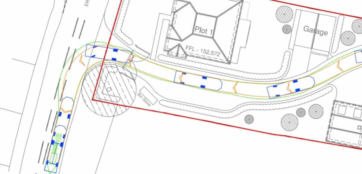
Swept Path Analysis example, Image provided by Lapworth Architects
How Do You Get a Swept Path Analysis?
If you are in need of a swept path analysis for your development project, here’s a step-by-step guide to obtaining one:
1. Engage a Professional Service
Swept path analysis requires specialised software and technical expertise. There are firms that specialise in performing this type of analysis, and it’s often best to leave it to professionals to ensure accuracy and compliance with local regulations.
2. Provide Detailed Site Information
The accuracy of a swept path analysis depends on the quality of the information provided. You'll need to supply detailed site layouts, typically obtained through mapping services. MapServe® can supply these high-quality maps, ensuring the site layout you provide is accurate and up to date.
3. Review the Analysis Results
Once the swept path analysis is complete, you will receive a detailed report outlining how the vehicles move through the space. Review the report with your designers and planners to determine whether any changes are needed to the site layout.
4. Make Necessary Adjustments
If the analysis identifies problem areas where vehicles may struggle, such as tight corners or access points, you will need to make design adjustments. This might include widening roads, altering parking layouts, or modifying entry/exit points to ensure safe and efficient vehicle movement.
Common Scenarios Where Swept Path Analysis Is Used
1. Parking and Loading Areas
In developments such as shopping centres, office buildings, and residential complexes, ensuring that vehicles can access parking or loading bays safely is essential. Swept path analysis confirms whether cars, delivery vans, or even larger vehicles can navigate the spaces provided.
2. Road and Junction Design
For new roads or altered roadways, it’s important to confirm that vehicles, including public transport and emergency services, can safely negotiate corners, roundabouts, and other junctions. Swept path analysis is used by highway authorities and planners to validate these designs.
3. Emergency Vehicle Access
In any development, ensuring that emergency vehicles—such as fire engines and ambulances—can access all areas of a site is critical. Swept path analysis helps ensure that these vehicles can respond swiftly in case of an emergency, even in tightly spaced developments.
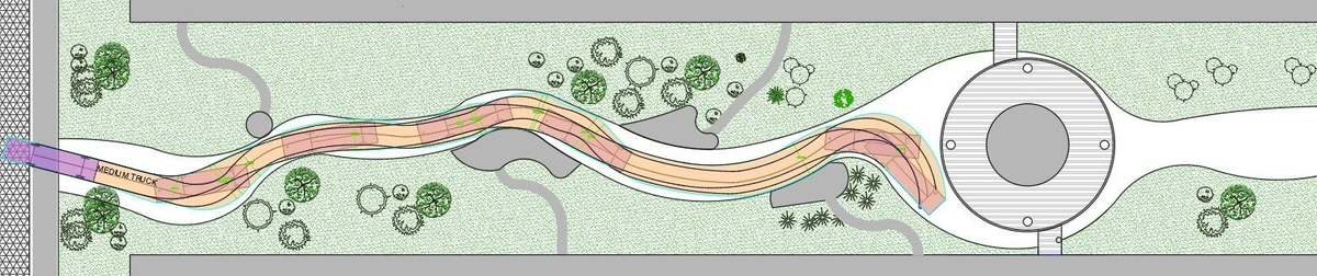
Basic Swept Path Analysis example, Image provided by CGS LABS
Why Accurate Mapping Is Essential for Swept Path Analysis
The foundation of a successful swept path analysis lies in accurate site maps. Without precise data on road dimensions, obstacles, and other features, the analysis could lead to incorrect conclusions and costly design errors. At MapServe®, we offer highly detailed Ordnance Survey maps that are specifically tailored for planning and development purposes. By using these maps, you can ensure that your swept path analysis is based on the most accurate and up-to-date data available.
Swept path analysis is an indispensable tool for any development project involving vehicle movement. It ensures safety, compliance with regulations and cost-efficiency by identifying potential issues early in the design process.
If you’re ready to get started, you can visit MapServe® to purchase the detailed site maps necessary for your project. Accurate mapping is the first step toward a successful swept path analysis, helping you ensure that your development meets the highest standards of safety and functionality.
To arrange a consultation, commission a project, or simply learn more, contact Jamie at [email protected].