We are delighted to announce the addition of the Land Use layer to our OS MasterMap® data offerings, now available in CAD format. This new layer provides detailed insights into how land is utilised across Great Britain, making it an invaluable resource for professionals in planning, environmental management, property, and more.
Download OS MasterMap with Land Use
What is the Land Use Layer?
The Land Use layer is a comprehensive dataset that classifies land based on its current usage. It covers a wide array of categories, including residential areas, commercial zones, agricultural land, industrial sites, recreational spaces, and transport infrastructures. With over 60 million individual land parcels mapped, this granular level of detail allows users to understand the distribution and extent of different land uses within any given area in the UK.
Detailed Classifications
The dataset includes specific classifications such as:
- Residential: Detached houses, semi-detached houses, terraced housing, flats, and apartments.
- Commercial: Retail spaces, offices, shopping centres, and business parks.
- Agricultural: Arable land, pasture, orchards, and horticultural areas.
- Industrial: Factories, warehouses, and energy production sites.
- Recreational: Parks, sports grounds, playgrounds, and nature reserves.
- Transport: Roads, railways, airports, and ports.
Key Features of the Land Use Layer
- Detailed Classification: Offers precise categorisation of land parcels, enabling accurate identification of land use types down to individual plots.
- Up-to-Date Information: Regular updates ensure the data reflects the most current land use, accounting for new developments and changes, with updates aligning with Ordnance Survey's release schedule.
- Seamless Integration: Designed to work harmoniously with other OS MasterMap® layers, such as Topography and Highways, providing a comprehensive geospatial dataset for the UK.
- CAD Compatibility: Available in CAD format for easy incorporation into existing design and planning workflows, supporting DWG and DXF formats.
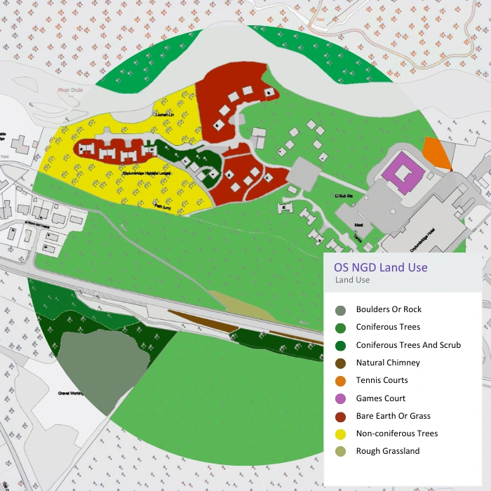
Land Use categories, including tree and ground types. Image provided by the OS.
Use Cases of the Land Use Layer
Urban Planning and Development
Site Selection and Feasibility Studies: Urban planners and developers in the UK face the challenge of accommodating a growing population, projected to reach 70 million by 2031. The Land Use layer assists in identifying suitable sites for development by:
- Analysing Land Availability: Quickly identify undeveloped or underutilised land within urban areas, essential for brownfield development strategies encouraged by the UK government.
- Compliance with Planning Regulations: Ensure proposed developments align with the National Planning Policy Framework (NPPF), which emphasises sustainable development and efficient use of land.
- Assessing Surrounding Uses: Evaluate the compatibility of new developments with existing land uses to minimise conflicts and enhance community integration.
Strategic Growth Planning: With the UK aiming to build 300,000 new homes annually, strategic planning is crucial. The Land Use layer aids in:
- Infrastructure Planning: Align housing developments with transport links, schools, and healthcare facilities.
- Green Belt Analysis: Identify areas where development is permissible without encroaching on protected Green Belt land, which constitutes about 13% of England's land area.
- Urban Regeneration: Support initiatives in areas like the Northern Powerhouse by identifying opportunities for economic growth and redevelopment.
Community Engagement: Effective planning involves the community. The Land Use layer facilitates:
- Visual Communication: Create detailed maps to present to local councils and residents, enhancing transparency.
- Impact Assessment: Demonstrate how proposed developments will affect local land use, traffic, and services.
- Feedback Integration: Incorporate community input by visualising suggestions and concerns within the land use context.
Environmental Management and Conservation
Ecosystem Assessment: The UK is home to diverse ecosystems, from Scottish Highlands to coastal wetlands. The Land Use layer supports environmental efforts by:
- Biodiversity Mapping: Identify habitats of endangered species; for example, only 2% of the UK's original wildflower meadows remain.
- Protected Areas Monitoring: Manage Sites of Special Scientific Interest (SSSIs), which cover over 1 million hectares, by monitoring land use changes that could impact them.
- Pollution Control: Assess areas at risk of pollution due to industrial land uses adjacent to sensitive environments.
Sustainable Resource Management: Agriculture occupies about 70% of UK land. The dataset aids in:
- Crop Planning: Help farmers optimise land use for crop rotation and sustainable practices.
- Forestry Management: Monitor woodlands, which cover 13% of the UK, for conservation and commercial use.
- Water Resource Protection: Identify land uses that could affect watersheds and aquifers, essential for maintaining clean water supplies.
Climate Change Mitigation: As the UK commits to net-zero greenhouse gas emissions by 2050, land use plays a vital role:
- Carbon Sequestration: Identify areas suitable for tree planting; the government aims to plant 30,000 hectares of new woodland annually.
- Renewable Energy Sites: Locate potential sites for wind farms or solar parks, considering land use constraints.
- Flood Risk Reduction: Implement land use strategies to enhance natural flood management in areas prone to flooding, such as along the River Thames.
Transportation and Infrastructure Planning
Optimising Transport Networks: With over 37 million vehicles on UK roads, efficient transport planning is essential
- Route Planning: Design new roads or railways like HS2 with minimal disruption by analysing current land uses.
- Public Transport Access: Improve connectivity in underserved areas by identifying gaps in transport networks.
- Cycle and Footpath Development: Promote sustainable transport by planning routes through appropriate land uses.
Infrastructure Development: Upgrading the UK's infrastructure requires detailed land use data
- Utility Placement: Plan the expansion of utilities like broadband networks, supporting initiatives like Project Gigabit.
- Energy Infrastructure: Locate sites for energy generation and distribution, crucial for meeting future energy demands.
- Housing Infrastructure: Coordinate the development of essential services for new housing estates.
Risk Assessment: Understanding land use is critical for safety
- Flood Risk Areas: Identify developments in Flood Zones 2 and 3, as designated by the Environment Agency, to implement appropriate safeguards.
- Contaminated Land: Detect previous industrial sites that may require remediation before development.
- Geological Hazards: Assess risks such as subsidence or landslides in areas like the Jurassic Coast.
Property and Real Estate
Market Analysis: The UK property market is dynamic and influenced by land use
- Trend Identification: Recognise emerging hotspots, such as the regeneration of East London's Docklands.
- Value Assessment: Understand that properties near green spaces like Hyde Park can command premiums of up to 20%.
- Investment Opportunities: Spot areas where land use changes indicate growth potential, such as shifts from industrial to residential zoning.
Valuation and Appraisal: Accurate valuations are essential for sales and development
- Comparative Analysis: Use land use data to compare similar properties and assess fair market value.
- Amenity Proximity: Factor in the influence of nearby schools, shops, and transport links on property desirability.
- Development Potential: Identify underutilised properties with potential for redevelopment, adding value.
Due Diligence: Before transactions, thorough analysis mitigates risk
- Land Use Restrictions: Uncover any planning restrictions or protected statuses that could affect property use.
- Historical Land Use: Investigate previous uses that might pose environmental risks, such as old landfill sites.
- Legal Compliance: Ensure all aspects comply with UK property laws and regulations.
Academic Research and Education
Urban Studies and Geography: Educational institutions benefit from real-world data
- Spatial Analysis: Students at universities like UCL and Oxford use land use data to study urban sprawl and city planning.
- Socio-Economic Studies: Analyse the relationship between land use and social factors, such as deprivation indices.
- Historical Comparisons: Examine how land use has evolved over time, informing future predictions.
Environmental Science: Research into environmental impacts relies on accurate data
- Land Use Change: Study deforestation rates or urbanisation impacts on wildlife.
- Conservation Strategies: Develop plans to protect habitats, supported by detailed land mapping.
- Climate Models: Incorporate land use data into models predicting climate change effects.
Planning and Architecture Education: Practical experience enhances learning
- Design Projects: Students create proposals using real land data, preparing them for professional roles.
- Policy Analysis: Examine the effectiveness of planning policies using tangible examples.
- Technology Integration: Learn to use CAD and GIS tools with actual datasets, improving technical skills.
Government and Public Services
Policy Development: Informed policies lead to better outcomes
- Housing Strategies: Use data to plan for housing shortages, as seen in the Affordable Homes Programme.
- Economic Planning: Identify areas for economic stimulus, such as Enterprise Zones.
- Environmental Legislation: Craft laws protecting green spaces, informed by accurate land use mapping.
Public Health and Safety: Land use impacts community well-being
- Healthcare Accessibility: Plan the placement of new hospitals or clinics to serve population needs.
- Recreational Spaces: Ensure equitable access to parks and leisure facilities, promoting physical activity.
- Air Quality Management: Monitor industrial areas affecting air quality, addressing public health concerns.
Taxation and Land Management: Efficient management enhances revenues
- Council Tax Assessment: Determine property bands accurately based on land use and value.
- Business Rates: Assess commercial properties fairly, supporting local government funding.
- Land Registry: Maintain up-to-date records, aiding in legal clarity and transaction efficiency.
Emergency Services and Disaster Management
Response Planning: Preparation can save lives
- Resource Allocation: Position fire stations and ambulance services optimally based on land use and population density.
- Evacuation Routes: Plan clear paths in densely built-up areas for emergencies.
- Critical Infrastructure Identification: Protect assets like power stations and hospitals by understanding their locations and surrounding land uses.
Risk Mitigation: Proactive measures prevent disasters
- Flood Defence Planning: Implement barriers or natural flood management in high-risk areas, such as parts of Somerset Levels.
- Fire Risk Assessment: Monitor land use changes that increase fire risks, like the conversion of areas to dry grasslands.
- Industrial Hazard Monitoring: Keep track of hazardous sites to prevent incidents like the Buncefield oil depot explosion in 2005.
Recovery Efforts: Effective recovery minimises long-term impacts
- Damage Assessment: Use land use data to quickly assess affected areas after events like the 2015 Cumbria floods.
- Resource Deployment: Coordinate rebuilding efforts efficiently, prioritising essential services and infrastructure.
- Community Support: Identify areas needing additional aid, ensuring equitable recovery assistance.
Illustration showing how the two feature types in the OS NGD Land Use Features Collection appear using a background map to provide context.
Image provided by the OS.
The addition of the Land Use layer to our OS MasterMap® data offerings marks a significant advancement for professionals across various sectors in the UK. With its detailed classifications and up-to-date information, this dataset empowers you to make informed decisions, plan more effectively, and contribute to sustainable development. Whether you're shaping the future of urban landscapes, conserving natural environments, enhancing infrastructure, or analysing market trends, the Land Use layer provides the essential insights you need.